


Les Arcs Michel

aljac
User
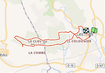

Length
9.6 km

Max alt
231 m

Uphill gradient
215 m
Km-Effort
12.5 km

Min alt
70 m

Downhill gradient
213 m
Boucle
Yes
Creation date :
2022-11-04 12:53:01.25
Updated on :
2022-11-04 15:25:04.993
2h31
Difficulty : Easy

FREE GPS app for hiking
 SityTrail
IGN / Geographical institutes
SityTrail Plus
The world is yours!
About
Trail Walking of 9.6 km to be discovered at Provence-Alpes-Côte d'Azur, Var, Les Arcs-sur-Argens. This trail is proposed by aljac.
Positioning
Country:
France
Region :
Provence-Alpes-Côte d'Azur
Department/Province :
Var
Municipality :
Les Arcs-sur-Argens
Location:
Unknown
Start:(Dec)
Start:(UTM)
296275 ; 4815153 (32T) N.
Comments